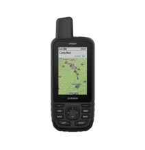
Características:
Incluye:
Dimensiones: 6 2 x 16 3 x 3 5 cm (2 5″ x 6 4″ x 1 4″)
Peso: 230g
MAPAS Y MEMORIA.
| MAPAS PREINSTALADOS | Sí (TopoActive de EE. UU. México y Canadá con rutas) |
|---|---|
| POSIBILIDAD DE AGREGAR MAPAS | SI |
| MAPA BASE | SI |
| CREACIÓN AUTOMÁTICA DE RUTAS (GIRO A GIRO EN CARRETERA) | SI |
| SEGMENTOS DEL MAPA | 15000 |
| BIRDSEYE | Sí (directamente al dispositivo) |
| INCLUYE CARACTERÍSTICAS HIDROGRÁFICAS DETALLADAS (LITORALES LÍNEAS DE COSTA DE RÍOS O LAGOS HUMEDALES ARROYOS PERENNES Y ESTACIONALES). | SI |
| INCLUYE BÚSQUEDAS DE PUNTOS DE INTERÉS (PARQUES CAMPINGS MIRADORES PANORÁMICOS Y SITIOS DE PÍCNIC). | SI |
| MUESTRA PARQUES NACIONALES ESTATALES Y LOCALES BOSQUES Y ÁREAS NATURALES. | SI |
| ALMACENAMIENTO Y CAPACIDAD DE CARGA | Sí (tarjeta microSD™ de 32 GB como máximo) |
| WAYPOINTS | 10000 |
| TRAYECTOS | 250 200 puntos de trayecto por trayecto |
| PISTAS | 250 |
| TRACK LOG | 20000 puntos 250 tracks gpx guardados 300 actividades de ejercicio guardadas |
| ACTIVIDADES | Sí |
| RUTAS | 250 250 puntos por ruta; 50 puntos de rutas automáticas |
SENSORES
| ECEPTOR DE ALTA SENSIBILIDAD | SI |
|---|---|
| GPS | SI |
| GLONASS | SI |
| GALILEO | SI |
| QZSS | SI |
| BEIDOU | SI |
| IRNSS | SI |
| ALTÍMETRO BAROMÉTRICO | SI |
| BRÚJULA | Sí (tres ejes con inclinación compensada) |
| BRÚJULA GPS (MIENTRAS SE ESTÁ EN MOVIMIENTO) | SI |
| FRECUENCIA MULTIBANDA | SI |
FUNCIONES PARA ACTIVIDADES DE OCIO Y AL AIRE LIBRE
| AVEGACIÓN PUNTO A PUNTO | SI |
|---|---|
| TRACBACK® | SI |
| CÁLCULO DE ÁREAS | SI |
| CALENDARIO DE CAZA Y PESCA | SI |
| INFORMACIÓN ASTRONÓMICA | SI |
| XERO™ LOCATIONS | SI |
| MODO GEOCACHING | Sí (geocachés en directo)< |
16 otros productos de la misma categoría: